Tuesday, January 24, 2012

Routeburn Caples


The Routeburn is one of the shorter great walks in New Zealand at just 32km. The hike is one of three great walks that need to be booked in advance (we booked it about a month before we wanted to do it because spaces were filling up). It is usually done in three days from one end to the other but can be combined with other walks to form a sort of loop. Since we had a car that we needed to get back to we decided to combine the Routeburn with the Caples Track to make the loop.

The night before starting the hike we stayed at a backpacker in Kinloch at the north end of Lake Wakatipu. The backpacker provided a shuttle to the Routeburn Shelter at the start of the trail. From there we walked up the Route Burn River. It was a wonderful, sunny day and the birds were out in full force so we were serenaded as we went. After about an hour of walking the trail headed away from the river and up into the Southern Alps. We reached the Routeburn Falls Hut in time for lunch and were rendered speechless by the views from its deck.

The weather forecast was for a change for the worse over night so we decided to take advantage of the sunshine by venturing up to the highest point on the trail. As we hiked up the trail the views got more and more spectacular. Our verbal skills are not good enough to explain what we saw and the pictures we took are only a poor caricature of the landscape. By the time we made it through Harris Saddle to the top of Conical Hill we knew that we were lucky to be experiencing one of the most incredible places in the world. We made it safely back to the Routeburn Falls Hut and took a refreshing dip in the river before celebrating Jenni’s 30th birthday.

We woke up to rain falling on the roof of the hut and got on the trail as quickly as we could. The swirling clouds gave the valley a ghostly look. Gone were the impressive peaks of the day before but in their place were mountains shrouded in mystery. It rained on us until we reached Harris Saddle. At that point the sun broke through and a rainbow appeared out of the mist. It was an incredible sight and a good sign for the rest of our walk that day. From there on we did not experience a drop of rain and the wind at our backs dried us out. At times the wind gusted so strongly that we felt like a helping hand was pushing us along. It did not bother us, but we felt for the people who were walking in the other direction.

With the help of the wind we quickly reached the valley overlooking Lake MacKenzie and headed down the hill to the Lake MacKenzie Hut. Just before we reached the hut we passed through Fairy Glen, a forest that appears to have been tailored for a Lord of the Rings movie set. It is made up of gnarled beech trees with branches twisted in fantastic directions, moss covering all the right places and ferns that ensure everywhere you look is green. As we rushed into the hut, the sky opened up and rain began pouring down. We lit a fire to warm the place up and tried to sympathize with the soaking people who arrived behind us. Just before we had dinner the rain stopped and the sun came out. We got some incredible views up the valley behind the lake and across the Hollyford River into the Darran Mountains which Sir Edmund Hillary used as one of his practice areas before climbing Mt. Everest.

The rain stayed away for the day so we had a short, pleasant walk to the Lake Howden Hut on our third day. The highlight of the walk was the 174m Earland Falls. After a quick snack at Lake Howden we hiked up to Key Summit to try to get some views down the Hollyford Valley. Unfortunately the clouds did not cooperate so we did not get the postcard picture that we were hoping for. We had to settle for exploring the beautiful alpine vegetation on the summit before heading back down to the hut.

The next morning we left the Routeburn Track and headed for the Caples Valley. The track from Lake McKellar to McKellar Saddle was rerouted recently and is now a smooth, wide path. Our view from the pass was wonderful, but it was hard to fully appreciate it after the views we had seen on the Routeburn. The new trail from McKellar Saddle into the Caples Valley is still being worked on so we got to walk on the original trail which is very rocky and covered in tree roots. It was fun jumping from root to root as long as we stayed on our feet. We arrived at the Upper Caples Hut just in time to have lunch. The plan was to stay the night there, but the DOC hut warden who was also having lunch there told us that the Mid Caples Hut down the valley had a much nicer view with far fewer sandflies. The walk to the Mid Caples Hut took another two hours and was entirely worth the extra effort. We had a beautiful view back up the valley as we ate our dinner.

Our extra walking on the fourth day meant that we could sleep in and still make it to our shuttle so we did. After breakfast and a short walk to explore the Caples River Gorge just below the hut we got on the trail. The hike out followed the Caples River until it met up with the Greenstone River and then followed that river to the parking lot where our shuttle picked us up.

It was nice to have a hot shower at the end of the day, but there was also some sadness at leaving such a beautiful area. It was an absolutely incredible walk and we were only rained on once which is pretty incredible for Fiordland. If you get a chance we would absolutely recommend the walk even if it is full of other tourists.


Tuesday, January 17, 2012

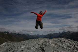
Jenni Jumped Out of a Plane


Kepler Track


The Kepler Track is another of New Zealand’s Great Walks. It is one of three Great Walks in Fiordland and was built in the mid 80s to try to reduce the number of people hiking the other two main trails in the area. Unfortunately most people are like us and want to hike all three so the track did not do much to alleviate the number of walkers.

The Kepler Track is a loop walk that starts and ends at the control gates of Lake Te Anau just outside of the Te Anau township. The recommended way of walking the track is counterclockwise, but when we booked the track the only way available was clockwise. The walk is about 60 kilometers long, but parts of the track can be skipped if you take water taxis or get picked up by shuttles at alternative exits.

Our first day of hiking was in the rain from the control gates to the Moturau Hut. Most of the day was under the cover of beech forest so the rain got us wet, but not unpleasantly so. The walk follows the Waiau River for most of the day before heading past the Te Anau wetlands and to the shores of Lake Manapouri. The lakefront beach near the Moturau Hut had some incredible views of the sun setting over the mountains so we went to bed with that image in our head.

We woke up to pouring rain. It seemed that the drought that Fiordland had been experiencing for the last month was broken. Much of the hike was under the cover of beech forest, but about an hour before we reached the Iris Burn Hut we came out into a clearing that was the result of a large 1984 landslide. Whatever parts of us were still dry at that point got soaked so we felt (and probably looked) like a couple of drowned rats when we reached the hut. Fortunately the hut had a wood stove and some firewood so we lit the fire and got warmed up while eating our dinner.

On the third day of hiking we found out why clockwise is the suggested way to do the walk. Over our first two hours of hiking we gained 900 meters (2,950 feet) in elevation from 450 meters to 1,350 meters. The tree line ended at around 1,000 meters so from there on we were exposed to the wind and rain. While we were still on the side of the hill climbing it was not so bad, but once we reached to top of the ridge it felt like we could be blown away. Our raingear had seemed good at the start of the walk, but we soon found that it did not stand much of a chance against sideways rain. There were a few good views of the area before we got to the Hanging Valley Shelter but from there to the Luxmore Hut we did not get to see much but white stuff. Thankfully when we arrived at the Luxmore Hut the people who had come from the opposite way already had the fire going so we were able to quickly get out of our wet gear and warm up. The Luxmore Hut is above the tree line and in the afternoon there was a little bit of clearing so we got some terrific views.

The rain had seemed to let up over night and we could not hear any falling when we woke up. It was not until we looked out the window that we realized that precipitation had fallen all night in the form of snow. Even at 1,000 meters snow is quite unusual in January so it was a real treat to see the area covered in such a beautiful frosting. We felt for the people who had to do the alpine crossing in the snow as we headed down the hill to the relative warmth of the lakeside. It was an easy hike down and we shared it with a couple from Australia, which made it pass even more quickly. We were back at the control gates before we knew it and in the car on our way to Queenstown.
The reward at the end of the hike (Fergburger)

Thursday, January 12, 2012

Doubtful Sound


We spent about ten days making new friends in Northern Otago and Southland before journeying into Fiordland. Fiordland is in the southwest corner of the South Island and is often considered the most beautiful part of New Zealand. The area gets its name from the deep valleys carved by glaciers during the last ice age.

Doubtful Sound is one of the deepest fiords in New Zealand with a maximum depth of over 500 meters. To get to the sound we had to take a water taxi from Manapouri across Lake Manapouri to the West Arm power station (check that out on wikipedia if you like feats of engineering) and then a bus across Wilmot Pass to Deep Cove mooring. The views getting to Doubtful Sound were impressive, but they certainly had not prepared us for the incredible beauty of the sound.

The boat we were got on, Tutoko II, is operated by Fiordland Expeditions and has three crew members who service a maximum of twelve tourists on each overnight cruise. There were nine others on the trip with us and we quickly got to know them over lunch as we cruised through the sound. We checked a couple of cray pots on our way out to the Tasman Sea. The sea was a bit rough so we were not able to go out as far as the skipper had hoped. When we got back into the sound we found a spot to do some fishing to catch the rest our dinner. There were a number of small rock perch caught as well as a dog shark and a groper.

After catching enough for dinner the skipper took us to an anchorage near Blanket Bay. We went for a short paddle in kayaks before jumping in for a refreshing swim. Our dinner was incredible. It started with a curried squash soup followed by half a crayfish and then potatoes with rock perch and groper before finishing with a sticky pudding. By the time we went to bed the wind had died down and there was not even a hint of a wave on the sound.


It showered over night so in the morning we got to see Doubtful Sound blanked in low clouds. It is one of the few times that we have been disappointed that there was not more rain because the rain makes the sound even more beautiful. The small shower we experienced created a number of new waterfalls, but if there is real rain waterfalls cascade down the steep slopes throughout the sound. After breakfast the boat started heading back to Deep Cove.

Along the way we saw a pod of bottle nosed dolphins, were able to dip our heads in a waterfall from the front of the boat and went a short distance up one of the sound’s arms. It was sad when we finally docked and took the bus and water taxi back to Manapouri. We are already planning our next trip to Doubtful Sound, but we need ten other people to come along. Any volunteers?

Saturday, January 7, 2012

Stewart Island and the Rakiura Track


The ferry ride to Stewart Island is known for its rough seas, but on the day we crossed Foveaux Straight it was as calm as a lake. We fell in love with Stewart Island the moment we stepped off the boat. Any thoughts of moving quickly vanished with the morning fog and a feeling of complete relaxation enveloped us.

Stewart Island is 45km wide and 60km long and has about 27km of road. The roads are concentrated around the only town on the island, Oban, and the rest of the island is designated a reserve. As a result of the large reserve the bird life on the island is better than almost anywhere else in New Zealand.


We celebrated a quiet Christmas at a hostel with other travelers before starting our first adventure on Stewart Island, the Rakiura Track. It is the shortest of the New Zealand Great Walks and can be done in two or three days. We chose to do it in three days to maximize our chances of seeing a Kiwi. We started the hike from Oban and walked on roads for about 7km to the official start of the track. From there we hiked out to Port Williams Hut. The area surrounding this hut is supposed to be the best opportunity on the Rakiura Track to see a Kiwi so we wandered around outside until 11:30 trying in vain to catch a glimpse of the shy birds. Unfortunately we only saw a couple of possums.
 
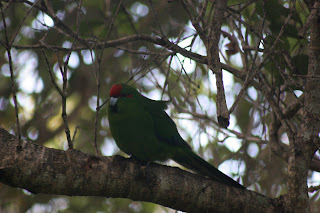
The second day from the Port Williams Hut to the North Arm Hut was a short, easy walk through regrowth forest. We passed a couple of old steam powered log haulers and spotted a few Red Headed Parakeets and Kakas along the way. We decided not to stay up looking for Kiwis because of our failure the night before. Soon after falling asleep we were awakened by a Kiwi’s piercing call. At the time we were too sleepy to get up, but we certainly regretted that in the morning.

Our last day of hiking from the North Arm Hut back to Oban was also very short and most of it was on an old logging road that runs out to Kaipipi Point so we decided to make it longer by walking Ryan’s Trail at the end of the day. We were happy that we did because Ryan’s trail runs along the water and we got some nice views of the Inlet and saw a couple of Kaka along the way.

The next adventure we had was going out to Ulva Island. Ulva Island is a small island in the middle of Paterson Inlet that is one of the only open bird sanctuaries in the world. There has been an extensive trapping program on the island to rid it of nonnative animals (mice, possums, stoats and the like) and it is now home to some beautiful, rare birds. We took a ferry from Oban to the island and explored it for six hours. We soon found that some of the birds on the island were used to not having predators around and would quite happily approach us. Others were a little harder to spot, but we managed to see almost all of them except the Kiwi.

On New Year’s Eve we went on a six hour, guided kayak trip in Paterson Inlet. Our guide from Rakiura Kayaks took us along the coast out to an abandoned Norwegian whaling base. Along the way we saw a number of blue penguins and our guide picked up a few shellfish for us to eat with lunch. After the trip we walked out to Acker’s Point before returning to town for the New Year’s festivities.

The South Sea Hotel doubles as the island’s only pub and for New Year’s they light a big bonfire on the beach in front of the pub. It seemed like the whole island turned out for the celebration along with almost an equal number of tourists. There was a band playing from the balcony of the hotel and people were dancing in the street well into the night. At midnight there was a huge display of fireworks (actually flares). It was quite lovely to see the harbor illuminated with a red glow.
In the morning we bid a sad farewell to Stewart Island and climbed on the ferry to head back to the mainland. It was a rough ride back across the straight, but some of that could be because we were still recovering from the evening before.

Can you spot the bird?