 We arrived at Lake Waikaremoana two nights before we were scheduled to hike around it. Upon our arrival at the lake’s main campground we were greeted by three guys who are following the All Blacks around the country in a converted delivery truck. The delivery truck was renovated with typical Kiwi ingenuity using shower doors for windows (shower doors are safety glass) and slept 4 fairly comfortably with couches that turned into bunks. We shared a few beers with the guys and they fed us a steak and kidney stew for dinner. The next day was fairly wet and uneventful. We picked up our tickets for the hike and changed our packing from camping to real camping.
Some people run the whole trail in around 5.5 hours, however most people take 3 or 4 days to walk around the lake. As it was our first overnight camping trip in New Zealand, we opted for the 4 day option. On the morning that we started the hike we took a shuttle (Route 38 phone: 06-837-3741 or mobile: 021-042-9972 just in case you ever need it) from just south of the lake to the north side where we were dropped off to begin the walk.
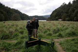 Our first day of tramping was quite a slog. It had been raining for the last few days and was even raining on us as we hiked. On this part of the walk the trail runs very close to the edge of the lake and goes through several very grassy, swampy areas that used to be the lakebed. Most of the track is on land that used to be lakebed because in 1946 a hydroelectric plant was installed at the outlet of the lake and Waikaremoana’s level was lowered as a result. It was impossible not to end up with wet feet and muddy shoes. We passed the first two huts that we saw (Whanganui and Waiharuru Huts) and were happy to finally see the Marauiti Hut where we were scheduled to stay. The hut had a wood burning stove in it and firewood was available so we had a warm evening to recover.
 The trail at the start of the second day was not nearly as muddy as it stayed a little farther away from the edge of the lake than the first day and it was all under forest cover. At around lunchtime we took a detour off the main track and headed to Korokora Falls. It was a wonderful side trip as we were able to leave our heavy pack on the main trail and hike quickly up to the falls. After lunch the trail got much muddier. It was also the only part of the trail that was not under tree cover and of course it rained. We arrived at the Waiopaoa Hut wet and grumpy, but our mood quickly changed as there was a family there who already had the fire going. We were soon warm and happy enjoying dinner in a cozy hut with some wonderful people that we had met along the way.
The third day was our favorite day of the hike. It was the only day of the hike that was uphill, but we had been so worried about it that it ended up being easier than we thought. It was the shortest day of hiking we had on the trail and we were rewarded with incredible views when we reached the Panekiri Hut. The Panekiri Hut was also the coldest place on the whole hike because it is on top of the Panekiri Bluffs so the wind comes howling off the lake and up the face of the bluff to buffet the hut. It was the only hut that did not have any firewood available, but we stayed warm by making friends and talking into the evening.
On our final day of hiking we got an early start because we had four hours of hiking to do and were scheduled to be picked up at noon. We hiked along the top of the bluffs for two hours getting some incredible views of the lake. The best views were from Bald Knob and if you ever hike the trail make sure that you take the time to go out there. It is a little hard to find because the trail is faint, but you will be richly rewarded if you can find it. No matter which direction you do the hike make sure that you take in the views between the Panekiri Hut and the trail end at Onepoto because they are by far the best views on the whole hike. We were both happy and sad to reach the end of the trail but thoroughly enjoyed the pies we rewarded ourselves with at Osler’s Bakery in Wairoa.
A few additional thoughts on the hike in case you ever do it:
Lake Waikaremoana was formed when a landslide blocked the Waikaretaheke River and the water filled up the river valley and the valleys of several streams that feed into it. This makes the lake have a very unique shape and means that as you hike you have to follow an uncountable number of inlets away from and then back toward the lake.
Make sure that you go see the Mokau Falls before you do the hike. They are accessible from a campground just below them.
We would recommend that you do the hike in a counterclockwise direction. It means that you save the hard part of the hike for later, but you also save the great views for the end of the hike.
The nicest huts on the track are the Waiharuru and the Waiopaoa so if you can manage it try to stay in those huts.
If you do the hike during the wet part of the year like we did then the track will be muddy, but the waterfall will be wonderful. As the track dries out so will the waterfall.
You have the choice of using a water taxi or a road taxi to get on and off of the hike and we would highly recommend the road taxi that we used because the driver is very knowledgeable and the pickup and drop off point he uses are very convenient if you are heading back to the east coast like we were.
The hike could easily be done in 3 days but doing it in 4 means that your hike is much more relaxed.
The rugby world cup final is tonight so
Go The All Blacks!

 After our hike around Lake Waikaremoana we drove down to Napier and found a local brewery so that we could treat ourselves to a well deserved cold one. Napier is located in the Hawkes Bay region of New Zealand and is known for its art deco buildings and wineries. We spent two days walking around town and driving out to a couple of wineries to have a taste. The highlight of our stay in Napier was the evening we got to spend with a woman we met on the Waikaremoana hike. She owns a nursery and works as a rural reporter so she had a lot of interesting information about New Zealand for us.

 In Wellington we met up with our friends from Alaska, Emily and Jason. They are on a short trip to New Zealand so we wanted to make sure that they could get as much out of it as possible. We took in the sights around Wellington including the botanical gardens, Te Papa (The Museum of New Zealand), Old St. Pauls, Weta Cave, the wineries in Martinborough and a couple of pubs that serve local beers.
 Our ferry ride from Wellington to Picton was wonderfully smooth and the passage through the Queen Charlotte Sound was beautiful. After landing on the South Island we drove straight to Blenheim. There is not much to do in Blenheim except visit the Marlborough region wineries and that is exactly what we did. We went on a full day tour of the wineries in the area with stops at a chocolate factory and a liquor store thrown in for good measure. In the evening we watch the Rugby World Cup final where New Zealand beat France 8-7. It was amazing how exciting such a low scoring game was. Emily and Jason flew out of Blenheim to Queenstown and we continued on to Nelson.
 Nelson bills itself as the sunniest place in New Zealand so of course it has been raining on us. Nelson is an arty city and we made it into town for the last day of the Urban Art Show and walked around town looking at all the objects that had been covered in knitting. We have been relaxing without any real plan, but we are hoping to do some hikes or find another helpx spot in the next few days.


